Mariposa Grove
I think this might be a long detour, a lot of biking up hill and the payout may not be high and we should not go here.
Trees
Water
- At the Mariposa Grove Welcome plaza and arrival area which is the head of the trail.
Bikes
- Bicycles are allowed on the Mariposa Grove Road between the Mariposa Grove Welcome plaza (near South Entrance) and the Grizzly Giant when the road is open for the season. Bicycles are not allowed elsewhere in the the Mariposa Grove.
Shuttle bus
- Buses arrive about every 15 minutes
- May 3 through September 23: 8 am to 7 pm (last bus leaves Mariposa Grove at 8:00 pm).
Official Map
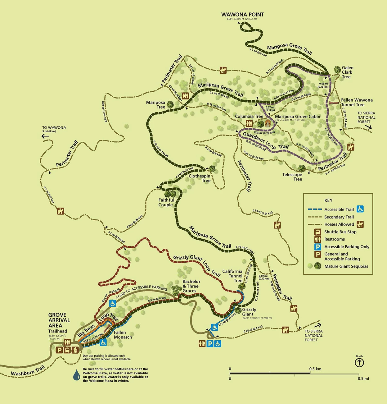
Bike route markers
One way distance: 2.8 miles (~25-30 minutes)
Elevation 736ft
The road climbs steadily uphill from the Welcome Plaza to the Grizzly Giant. It is possible that this will be difficult.
{"type":"Feature","properties":{},"geometry":{"type":"LineString","coordinates":[[-119.630091,37.507122],[-119.628601,37.507488],[-119.627957,37.507463],[-119.627373,37.507378],[-119.627062,37.507352],[-119.626424,37.507539],[-119.625974,37.507522],[-119.62577,37.507382],[-119.625513,37.507016],[-119.625364,37.506811],[-119.624849,37.506552],[-119.624116,37.506475],[-119.623805,37.506356],[-119.623654,37.506237],[-119.623622,37.505888],[-119.62388,37.505411],[-119.624009,37.505028],[-119.623923,37.504526],[-119.624095,37.504006],[-119.624342,37.50359],[-119.624417,37.503318],[-119.624385,37.503139],[-119.624427,37.502841],[-119.624535,37.502603],[-119.624953,37.502305],[-119.625512,37.502075],[-119.625802,37.501734],[-119.625855,37.501462],[-119.625726,37.500866],[-119.625759,37.500466],[-119.625855,37.50004],[-119.625877,37.499725],[-119.625512,37.499367],[-119.625136,37.499206],[-119.624728,37.499214],[-119.623536,37.499691],[-119.62315,37.500125],[-119.623043,37.500798],[-119.622656,37.501172],[-119.622034,37.501394],[-119.620176,37.501811],[-119.619489,37.501964],[-119.618963,37.501913],[-119.618727,37.501717],[-119.618534,37.50107],[-119.618362,37.500474],[-119.61818,37.500389],[-119.617514,37.500253],[-119.616988,37.50004],[-119.616677,37.500125],[-119.616033,37.500508],[-119.615303,37.500525],[-119.614744,37.500636],[-119.614369,37.500679],[-119.6138,37.500517],[-119.613424,37.500508],[-119.613155,37.500713],[-119.612748,37.501445],[-119.612468,37.501496],[-119.611932,37.501394],[-119.611245,37.501521],[-119.611235,37.501649],[-119.611246,37.501824],[-119.611241,37.502011],[-119.611109,37.502145],[-119.610532,37.502432],[-119.610355,37.502517],[-119.609923,37.502641],[-119.609577,37.502694],[-119.609307,37.5029],[-119.608987,37.503341],[-119.608768,37.503526],[-119.608599,37.503571],[-119.608352,37.50376],[-119.608107,37.503973],[-119.607992,37.504075],[-119.607702,37.504196],[-119.607349,37.504281],[-119.606885,37.504357],[-119.606144,37.504314],[-119.605478,37.504271],[-119.604963,37.504152],[-119.604555,37.50388],[-119.604319,37.503735],[-119.603997,37.503735],[-119.603514,37.503948],[-119.603322,37.503849],[-119.603287,37.503705],[-119.603483,37.503455],[-119.603628,37.503183],[-119.603725,37.502968],[-119.603741,37.502617],[-119.603648,37.502411],[-119.60353,37.502275],[-119.60335,37.502168],[-119.603124,37.502115],[-119.602794,37.50213],[-119.602681,37.502138]]}}
tag:bike-route tag:yosemite